There are five different "Street 1"s in Margalla Enclave. Before you compare two quotes, make sure both are on the same one.
Jump to a sector: North-East · West · Lake East · Lake West · South · South-West · South-East
The columns Plots found, Length and Nearest mosque are our own measurements from a dealer-circulated copy of the master plan sheet, not DHA figures; DHA publishes no street-wise register. Plots found is the number of plot numbers we could tie to the street on the drawing. Length runs between the first and last of those plots. Nearest mosque is the straight-line distance from the middle of the street to the nearest mosque label on the sheet, taken at 4.36 m per drawing point (a scale we worked out from plot frontages) and rounded to 10 m. It is not a walking route.
North-East sector — 1 Kanal, 64 streets
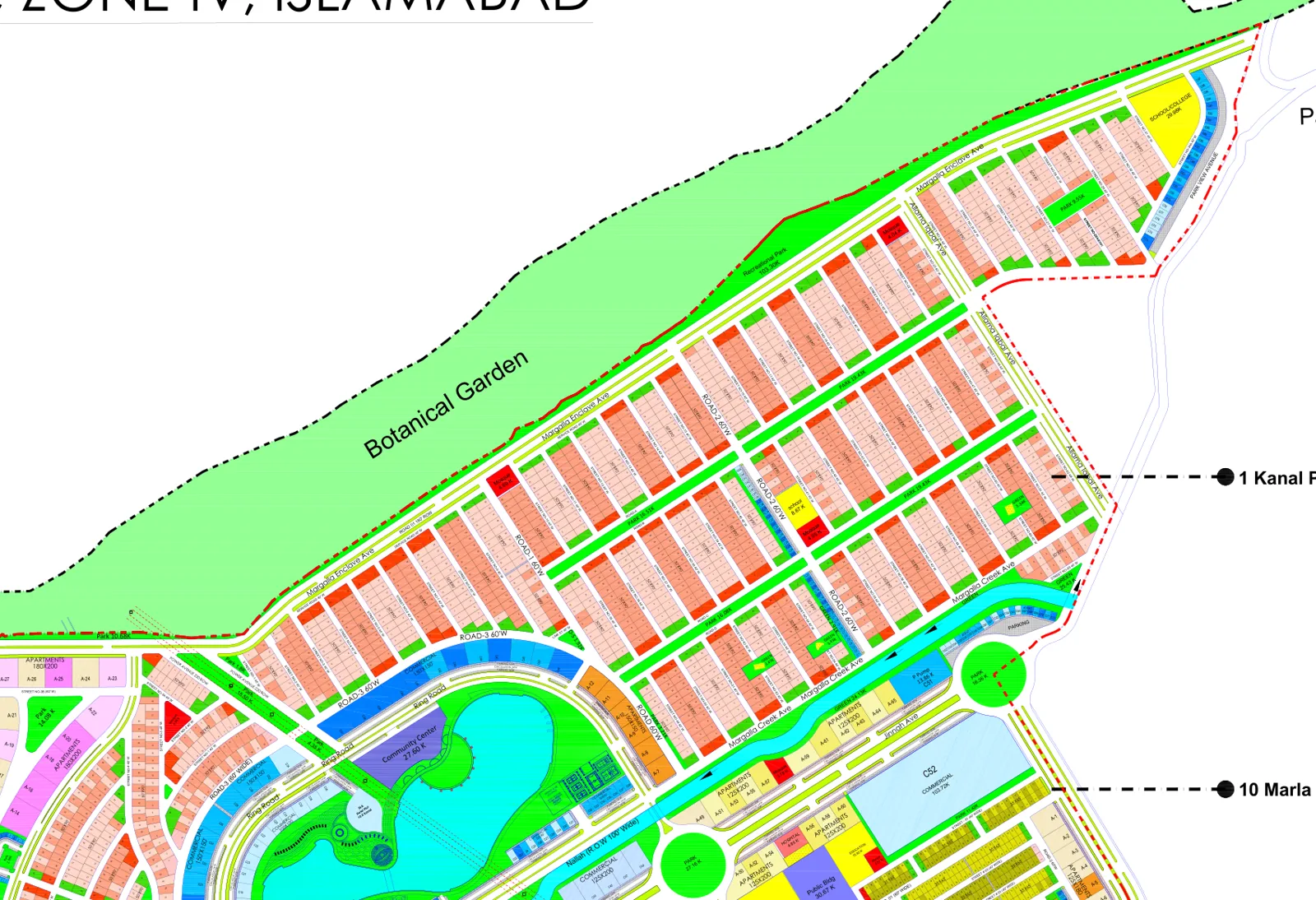
The large 1 Kanal grid between Margalla Enclave Avenue and the Botanical Garden edge, north of Margalla Creek Avenue — the biggest single block of streets on the sheet, numbered 1 to 63 from the lake end eastwards. By plot size this is a 1 Kanal area, which dealers market as ME-2, ME-3 or the Lake District. The sheet does not print the ME numbers, and neither DHA’s portal nor the EIA gives plot sizes per block, so treat a block name as unconfirmed until DHA confirms it in writing for your plot.
| Street | Plot size | Plots found | Numbers | Length | Nearest mosque |
|---|---|---|---|---|---|
| Street 1 | 1 Kanal | 29 | 1–33 | 580 m | 110 m |
| Street 2 | 1 Kanal | 35 | 1–61 | 170 m | 130 m |
| Street 3 | 1 Kanal | 29 | 1–45 | 410 m | 140 m |
| Street 3A | 1 Kanal | 13 | 2–46 | 280 m | 60 m |
| Street 4 | 1 Kanal | 24 | 1–24 | 180 m | 390 m |
| Street 5 | 1 Kanal | 24 | 1–24 | 180 m | 390 m |
| Street 6 | 1 Kanal | 24 | 1–24 | 180 m | 330 m |
| Street 7 | 1 Kanal | 27 | 1–27 | 210 m | 270 m |
| Street 8 | 1 Kanal | 32 | 1–32 | 260 m | 220 m |
| Street 9 | 1 Kanal | 39 | 2–40 | 300 m | 180 m |
| Street 10 | 1 Kanal | 25 | 1–27 | 250 m | 110 m |
| Street 11 | 1 Kanal | 27 | 1–28 | 250 m | 150 m |
| Street 12 | 1 Kanal | 27 | 1–27 | 250 m | 200 m |
| Street 13 | 1 Kanal | 27 | 1–28 | 250 m | 260 m |
| Street 14 | 1 Kanal | 27 | 1–27 | 250 m | 320 m |
| Street 15 | 1 Kanal | 26 | 1–26 | 200 m | 340 m |
| Street 16 | 1 Kanal | 27 | 1–27 | 270 m | 320 m |
| Street 17 | 1 Kanal | 27 | 1–27 | 250 m | 330 m |
| Street 18 | 1 Kanal | 27 | 1–28 | 250 m | 320 m |
| Street 19 | 1 Kanal | 27 | 1–27 | 250 m | 260 m |
| Street 20 | 1 Kanal | 27 | 1–28 | 250 m | 200 m |
| Street 21 | 1 Kanal | 27 | 1–27 | 250 m | 150 m |
| Street 22 | 1 Kanal | 25 | 1–28 | 250 m | 110 m |
| Street 23 | 1 Kanal | 13 | 1–14 | 240 m | 110 m |
| Street 24 | 1 Kanal | 14 | 1–14 | 210 m | 100 m |
| Street 25 | 1 Kanal | 27 | 1–27 | 210 m | 160 m |
| Street 26 | 1 Kanal | 30 | 1–30 | 240 m | 230 m |
| Street 27 | 1 Kanal | 31 | 1–31 | 270 m | 310 m |
| Street 28 | 1 Kanal | 15 | 1–15 | 120 m | 350 m |
| Street 28A | 1 Kanal | 9 | 1–12 | 70 m | 410 m |
| Street 29 | 1 Kanal | 31 | 1–34 | 300 m | 430 m |
| Street 30 | 1 Kanal | 25 | 1–26 | 210 m | 500 m |
| Street 31 | 1 Kanal | 10 | 2–11 | 150 m | 550 m |
| Street 32 | 1 Kanal | 6 | 9–16 | 40 m | 410 m |
| Street 34A | 1 Kanal | 4 | 1–6 | 200 m | 620 m |
| Street 35 | 1 Kanal | 23 | 1–28 | 210 m | 350 m |
| Street 36 | 1 Kanal | 24 | 1–27 | 210 m | 360 m |
| Street 37 | 1 Kanal | 25 | 1–28 | 210 m | 320 m |
| Street 38 | 1 Kanal | 26 | 2–27 | 210 m | 250 m |
| Street 39 | 1 Kanal | 26 | 1–28 | 210 m | 200 m |
| Street 40 | 1 Kanal | 27 | 2–28 | 210 m | 150 m |
| Street 41 | 1 Kanal | 19 | 1–19 | 210 m | 80 m |
| Street 42 | 1 Kanal | 27 | 1–28 | 210 m | 130 m |
| Street 43 | 1 Kanal | 27 | 1–27 | 210 m | 180 m |
| Street 44 | 1 Kanal | 27 | 1–28 | 210 m | 250 m |
| Street 45 | 1 Kanal | 27 | 1–27 | 210 m | 310 m |
| Street 46 | 1 Kanal | 26 | 1–28 | 210 m | 360 m |
| Street 47 | 1 Kanal | 27 | 1–27 | 210 m | 350 m |
| Street 48 | 1 Kanal | 12 | 1–12 | 180 m | 340 m |
| Street 49 | 1 Kanal | 26 | 1–26 | 200 m | 240 m |
| Street 50 | 1 Kanal | 26 | 1–26 | 200 m | 210 m |
| Street 51 | 1 Kanal | 26 | 1–26 | 200 m | 210 m |
| Street 52 | 1 Kanal | 22 | 1–22 | 260 m | 220 m |
| Street 53 | 1 Kanal | 26 | 1–26 | 260 m | 230 m |
| Street 54 | 1 Kanal | 22 | 1–22 | 260 m | 220 m |
| Street 55 | 1 Kanal | 26 | 1–26 | 200 m | 180 m |
| Street 56 | 1 Kanal | 26 | 1–26 | 200 m | 200 m |
| Street 57 | 1 Kanal | 26 | 1–26 | 200 m | 240 m |
| Street 58 | 1 Kanal | 26 | 1–26 | 200 m | 290 m |
| Street 59 | 1 Kanal | 26 | 1–26 | 240 m | 350 m |
| Street 60 | 1 Kanal | 20 | 1–20 | 330 m | 410 m |
| Street 61 | 1 Kanal | 26 | 1–26 | 270 m | 470 m |
| Street 62 | 1 Kanal | 13 | 1–13 | 240 m | 530 m |
| Street 63 | 1 Kanal | 4 | 1–8 | 120 m | 520 m |
West sector — 1 Kanal, 26 streets
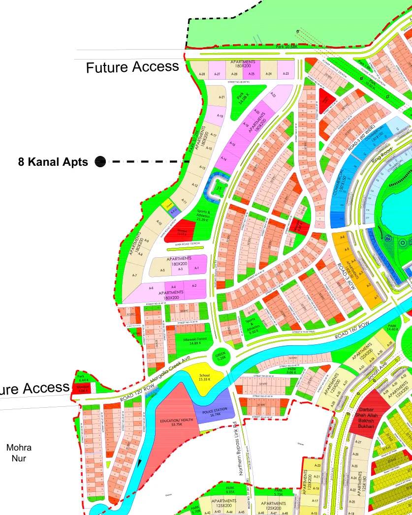
The 1 Kanal streets on the Mohra Nur side, between the western Future Access reservation and the lake, split by apartment parcels and parks. By plot size this is a 1 Kanal area, which dealers market as ME-2, ME-3 or the Lake District. The sheet does not print the ME numbers, and neither DHA’s portal nor the EIA gives plot sizes per block, so treat a block name as unconfirmed until DHA confirms it in writing for your plot.
| Street | Plot size | Plots found | Numbers | Length | Nearest mosque |
|---|---|---|---|---|---|
| Street 3B | 1 Kanal | 1 | 5–5 | 50 m | 280 m |
| Street 4 | 1 Kanal | 17 | 1–32 | 450 m | 200 m |
| Street 5 | 1 Kanal | 26 | 1–37 | 580 m | 30 m |
| Street 6 | 1 Kanal | 35 | 1–41 | 410 m | 100 m |
| Street 7 | 1 Kanal | 41 | 1–52 | 610 m | 170 m |
| Street 8 | 1 Kanal | 25 | 1–28 | 270 m | 240 m |
| Street 9 | 1 Kanal | 22 | 1–23 | 340 m | 250 m |
| Street 10 | 1 Kanal | 19 | 1–19 | 480 m | 280 m |
| Street 11 | 1 Kanal | 12 | 1–14 | 470 m | 300 m |
| Street 12 | 1 Kanal | 15 | 1–16 | 370 m | 360 m |
| Street 13 | 1 Kanal | 21 | 2–29 | 390 m | 210 m |
| Street 14 | 1 Kanal | 13 | 2–20 | 250 m | 250 m |
| Street 15 | 1 Kanal | 16 | 1–16 | 470 m | 360 m |
| Street 16 | 1 Kanal | 17 | 1–19 | 180 m | 320 m |
| Street 17 | 1 Kanal | 11 | 1–14 | 270 m | 260 m |
| Street 18 | 1 Kanal | 7 | 1–17 | 110 m | 250 m |
| Street 19 | 1 Kanal | 13 | 1–17 | 250 m | 450 m |
| Street 20 | 1 Kanal | 12 | 1–12 | 270 m | 490 m |
| Street 21 | 1 Kanal | 20 | 1–20 | 240 m | 550 m |
| Street 22 | 1 Kanal | 8 | 2–9 | 120 m | 580 m |
| Street 23 | 1 Kanal | 6 | 1–7 | 390 m | 450 m |
| Street 24 | 1 Kanal | 5 | 1–7 | 330 m | 400 m |
| Street 25 | 1 Kanal | 9 | 1–9 | 140 m | 230 m |
| Street 26 | 1 Kanal | 23 | 1–23 | 300 m | 170 m |
| Street 27 | 1 Kanal | 32 | 1–32 | 310 m | 130 m |
| Street 28 | 1 Kanal | 20 | 1–20 | 300 m | 150 m |
Lake East sector — 1 Kanal, 4 streets
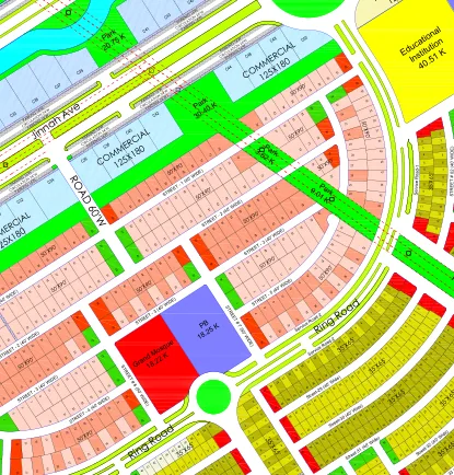
The short 1 Kanal streets inside the Ring Road on the east side of the lake. By plot size this is a 1 Kanal area around the lake, which dealers may market as the Lake District. The sheet does not print the ME numbers, and neither DHA’s portal nor the EIA gives plot sizes per block, so treat a block name as unconfirmed until DHA confirms it in writing for your plot.
| Street | Plot size | Plots found | Numbers | Length | Nearest mosque |
|---|---|---|---|---|---|
| Street 1 | 1 Kanal | 49 | 1–92 | 480 m | 570 m |
| Street 2 | 1 Kanal | 43 | 2–80 | 460 m | 620 m |
| Street 3 | 1 Kanal | 41 | 1–60 | 630 m | 600 m |
| Street 5 | 1 Kanal | 19 | 3–21 | 300 m | 640 m |
Lake West sector — 1 Kanal, 4 streets
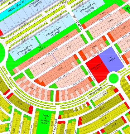
The short 1 Kanal streets inside the Ring Road on the south-west side of the lake. By plot size this is a 1 Kanal area around the lake, which dealers may market as the Lake District. The sheet does not print the ME numbers, and neither DHA’s portal nor the EIA gives plot sizes per block, so treat a block name as unconfirmed until DHA confirms it in writing for your plot.
| Street | Plot size | Plots found | Numbers | Length | Nearest mosque |
|---|---|---|---|---|---|
| Street 1 | 1 Kanal | 43 | 1–47 | 470 m | 320 m |
| Street 2 | 1 Kanal | 39 | 1–42 | 480 m | 370 m |
| Street 3 | 1 Kanal | 25 | 1–36 | 390 m | 350 m |
| Street 4 | 1 Kanal | 24 | 4–42 | 360 m | 350 m |
South sector — 10 Marla, 29 streets
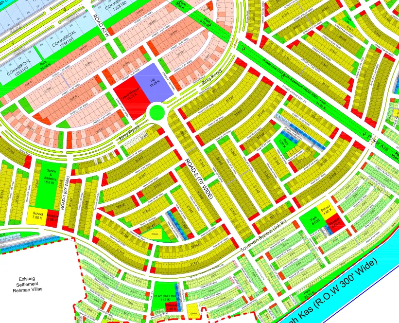
The central 10 Marla grid south of Margalla Creek Avenue, between the 150′ road and the Southern Bypass Link Road. By plot size this is a small-plot area, which dealers market as ME-1 or ME-4. The sheet does not print the ME numbers, and neither DHA’s portal nor the EIA gives plot sizes per block, so treat a block name as unconfirmed until DHA confirms it in writing for your plot.
| Street | Plot size | Plots found | Numbers | Length | Nearest mosque |
|---|---|---|---|---|---|
| Street 6 | 10 Marla | 13 | 6–47 | 420 m | 420 m |
| Street 7 | 10 Marla | 14 | 1–55 | 410 m | 570 m |
| Street 13 | 10 Marla | 36 | 1–181 | 350 m | 100 m |
| Street 14 | 10 Marla | 40 | 2–178 | 480 m | 150 m |
| Street 15 | 10 Marla | 36 | 1–46 | 420 m | 330 m |
| Street 16 | 10 Marla | 47 | 1–50 | 470 m | 330 m |
| Street 17 | 10 Marla | 44 | 1–50 | 370 m | 330 m |
| Street 18 | 10 Marla | 36 | 1–180 | 500 m | 340 m |
| Street 19 | 10 Marla | 39 | 2–175 | 450 m | 280 m |
| Street 19A | 10 Marla | 23 | 1–117 | 420 m | 240 m |
| Street 20 | 10 Marla | 35 | 1–103 | 570 m | 300 m |
| Street 21 | 10 Marla | 37 | 2–85 | 540 m | 340 m |
| Street 22 | 10 Marla | 75 | 1–151 | 590 m | 230 m |
| Street 23 | 10 Marla | 77 | 1–133 | 490 m | 200 m |
| Street 24 | 10 Marla | 46 | 1–71 | 520 m | 400 m |
| Street 25 | 10 Marla | 53 | 1–67 | 580 m | 380 m |
| Street 26 | 10 Marla | 39 | 2–55 | 520 m | 330 m |
| Street 27 | 10 Marla | 28 | 1–49 | 550 m | 260 m |
| Street 28 | 10 Marla | 25 | 1–44 | 470 m | 270 m |
| Street 29 | 10 Marla | 42 | 1–51 | 430 m | 550 m |
| Street 30 | 10 Marla | 45 | 1–55 | 450 m | 500 m |
| Street 31 | 10 Marla | 32 | 1–49 | 380 m | 450 m |
| Street 32 | 10 Marla | 30 | 1–37 | 540 m | 380 m |
| Street 33 | 10 Marla | 22 | 2–40 | 540 m | 330 m |
| Street 34 | 10 Marla | 20 | 1–32 | 600 m | 310 m |
| Street 35 | 10 Marla | 30 | 2–35 | 510 m | 350 m |
| Street 36 | 10 Marla | 26 | 2–49 | 530 m | 250 m |
| Street 37 | 10 Marla | 31 | 1–46 | 480 m | 200 m |
| Street 38 | 10 Marla | 46 | 1–64 | 530 m | 150 m |
South-West sector — 10 Marla, 12 streets
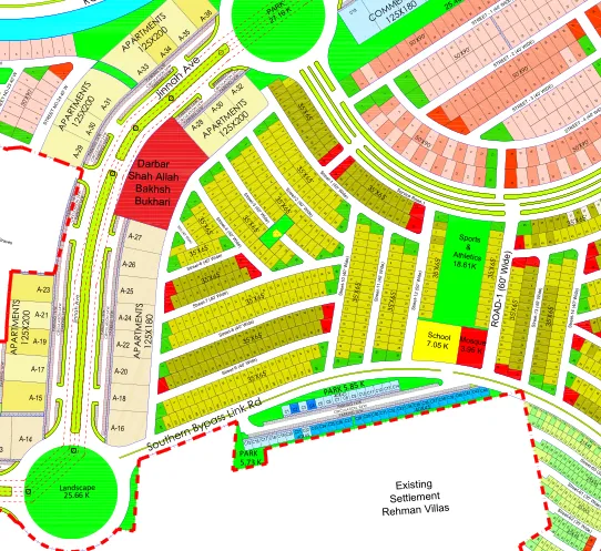
The 10 Marla streets west of the 150′ main road, towards the Darbar and the southern Future Access. By plot size this is a small-plot area, which dealers market as ME-1 or ME-4. The sheet does not print the ME numbers, and neither DHA’s portal nor the EIA gives plot sizes per block, so treat a block name as unconfirmed until DHA confirms it in writing for your plot.
| Street | Plot size | Plots found | Numbers | Length | Nearest mosque |
|---|---|---|---|---|---|
| Street 1 | 10 Marla | 33 | 1–37 | 330 m | 300 m |
| Street 2 | 10 Marla | 32 | 2–38 | 300 m | 310 m |
| Street 3 | 10 Marla | 34 | 1–36 | 360 m | 360 m |
| Street 4 | 10 Marla | 30 | 1–47 | 330 m | 380 m |
| Street 5 | 10 Marla | 22 | 1–187 | 290 m | 440 m |
| Street 6 | 10 Marla | 17 | 1–29 | 350 m | 400 m |
| Street 7 | 10 Marla | 27 | 1–41 | 380 m | 380 m |
| Street 8 | 10 Marla | 41 | 1–47 | 370 m | 340 m |
| Street 9 | 10 Marla | 44 | 1–48 | 360 m | 330 m |
| Street 10 | 10 Marla | 22 | 1–182 | 440 m | 200 m |
| Street 11 | 10 Marla | 30 | 3–40 | 430 m | 160 m |
| Street 12 | 10 Marla | 28 | 1–29 | 370 m | 110 m |
South-East sector — 10 Marla and 5 Marla, 59 streets
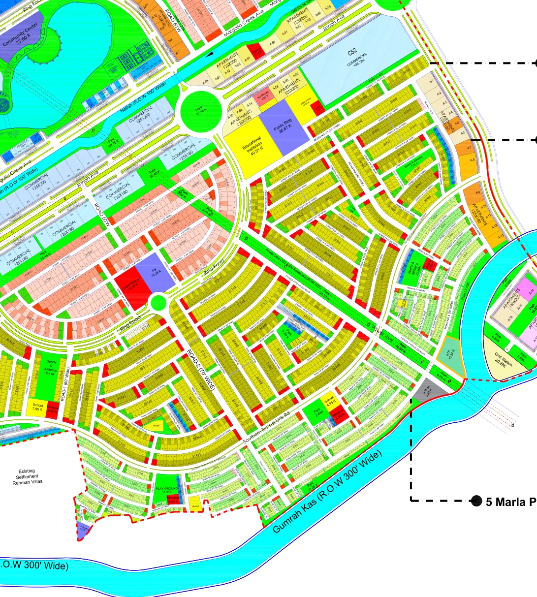
The streets on the Bahria Enclave side: 10 Marla on Streets 1–20 nearest Margalla Creek Avenue, then 5 Marla on Streets 21–65 running down to the Gumrah Kas. By plot size this is a small-plot area, which dealers market as ME-1 or ME-4. The sheet does not print the ME numbers, and neither DHA’s portal nor the EIA gives plot sizes per block, so treat a block name as unconfirmed until DHA confirms it in writing for your plot.
| Street | Plot size | Plots found | Numbers | Length | Nearest mosque |
|---|---|---|---|---|---|
| Street 1 | 10 Marla | 36 | 1–37 | 420 m | 390 m |
| Street 2 | 10 Marla | 19 | 2–92 | 390 m | 480 m |
| Street 3 | 10 Marla | 82 | 1–91 | 780 m | 400 m |
| Street 4 | 10 Marla | 43 | 1–72 | 710 m | 280 m |
| Street 5 | 10 Marla | 42 | 3–59 | 510 m | 470 m |
| Street 6 | 10 Marla | 46 | 1–54 | 490 m | 430 m |
| Street 7 | 10 Marla | 29 | 1–52 | 510 m | 390 m |
| Street 8 | 10 Marla | 32 | 2–85 | 490 m | 290 m |
| Street 9 | 10 Marla | 36 | 1–44 | 430 m | 320 m |
| Street 10 | 10 Marla | 45 | 1–54 | 590 m | 340 m |
| Street 11 | 10 Marla | 44 | 4–59 | 530 m | 370 m |
| Street 12 | 10 Marla | 23 | 1–29 | 460 m | 210 m |
| Street 13 | 10 Marla | 30 | 2–42 | 470 m | 160 m |
| Street 14 | 10 Marla | 47 | 1–61 | 700 m | 280 m |
| Street 15 | 10 Marla | 19 | 1–24 | 330 m | 230 m |
| Street 16 | 10 Marla | 26 | 1–28 | 320 m | 280 m |
| Street 17 | 10 Marla | 22 | 1–35 | 320 m | 340 m |
| Street 17A | 10 Marla | 34 | 1–49 | 570 m | 290 m |
| Street 18 | 10 Marla | 39 | 1–45 | 310 m | 390 m |
| Street 19 | 10 Marla | 18 | 1–30 | 460 m | 290 m |
| Street 20 | 10 Marla | 47 | 1–55 | 320 m | 440 m |
| Street 21 | 5 Marla | 42 | 1–50 | 420 m | 130 m |
| Street 22 | 5 Marla | 44 | 1–57 | 390 m | 120 m |
| Street 23 | 5 Marla | 37 | 1–64 | 380 m | 110 m |
| Street 24 | 5 Marla | 87 | 1–88 | 640 m | 90 m |
| Street 25 | 5 Marla | 21 | 2–48 | 510 m | 50 m |
| Street 26 | 5 Marla | 21 | 1–26 | 470 m | 160 m |
| Street 27 | 5 Marla | 24 | 1–30 | 430 m | 170 m |
| Street 28 | 5 Marla | 50 | 1–55 | 500 m | 180 m |
| Street 29 | 5 Marla | 28 | 1–83 | 400 m | 220 m |
| Street 39 | 5 Marla | 33 | 1–42 | 380 m | 230 m |
| Street 40 | 5 Marla | 29 | 1–40 | 270 m | 190 m |
| Street 41 | 5 Marla | 30 | 1–30 | 220 m | 110 m |
| Street 42 | 5 Marla | 31 | 1–34 | 360 m | 110 m |
| Street 43 | 5 Marla | 50 | 11–82 | 510 m | 110 m |
| Street 44 | 5 Marla | 74 | 1–105 | 480 m | 120 m |
| Street 45 | 5 Marla | 11 | 1–55 | 330 m | 70 m |
| Street 45A | 5 Marla | 27 | 1–86 | 270 m | 100 m |
| Street 46 | 5 Marla | 52 | 1–111 | 300 m | 210 m |
| Street 47 | 5 Marla | 37 | 1–89 | 550 m | 200 m |
| Street 48 | 5 Marla | 33 | 1–81 | 240 m | 190 m |
| Street 49 | 5 Marla | 44 | 1–71 | 420 m | 200 m |
| Street 50 | 5 Marla | 29 | 6–76 | 340 m | 250 m |
| Street 51 | 5 Marla | 13 | 1–114 | 80 m | 290 m |
| Street 52 | 5 Marla | 18 | 1–121 | 110 m | 320 m |
| Street 53 | 5 Marla | 11 | 1–124 | 90 m | 290 m |
| Street 54 | 5 Marla | 30 | 1–83 | 350 m | 260 m |
| Street 55 | 5 Marla | 29 | 1–115 | 190 m | 250 m |
| Street 56 | 5 Marla | 35 | 3–93 | 320 m | 180 m |
| Street 57 | 5 Marla | 40 | 1–86 | 280 m | 140 m |
| Street 58 | 5 Marla | 42 | 1–76 | 420 m | 140 m |
| Street 58A | 5 Marla | 27 | 1–95 | 260 m | 230 m |
| Street 59 | 5 Marla | 18 | 1–19 | 240 m | 50 m |
| Street 60 | 5 Marla | 53 | 2–63 | 370 m | 230 m |
| Street 61 | 5 Marla | 49 | 1–60 | 300 m | 240 m |
| Street 62 | 5 Marla | 43 | 4–54 | 210 m | 240 m |
| Street 63 | 5 Marla | 29 | 9–37 | 150 m | 210 m |
| Street 64 | 5 Marla | 13 | 1–13 | 80 m | 270 m |
| Street 65 | 5 Marla | 12 | 2–38 | 320 m | 300 m |
"Plots found" is the count of plot numbers the parser could tie to the street on the drawing, not DHA's allotment count; "length" is the plotted length between the first and last of those plots, to the nearest 10 m.
Master plan sheet (Kuri Road, Zone-IV): a dealer-circulated copy of a drawing that appears to be DHA's, PDF plotted 16 May 2025, read 19 September 2026. The sheet prints no date. Scale: 1 drawing point = 4.36 m, derived from the 50′, 35′ and 25′ plot frontages on the sheet itself (all three agree to within 2%). Provenance and what we removed.
Last checked . First published .
Which street should I look at?
Say your budget and whether you are building or holding; you get three streets to drive to, not a list.